



Behind China’s aircraft carriers lies the strategic depth of the Pacific, while behind Turkey lie increasingly transparent narrow seas.
One of the greatest mistakes made when discussing the future of naval power is to take the platforms possessed by major states and adopt them while ignoring their geographical and strategic conditions. Such linear approaches overlook the most fundamental variable of naval strategy: geography. The true value of a warship is measured not only by the capacity of the aircraft, missiles, or sensors it carries, but by where it will be located when war begins, what threats it will be exposed to, how long it can survive, and whether it can sustain the mission assigned to it. The US-Israel-Iran war has proven this situation with extremely powerful results. Since February 28, 2026, the US has been unable to bring its fleet into the Persian Gulf.
Turkey’s geopolitical destiny in the 21st century will be determined in the Mediterranean. This situation imposes a roadmap on Turkey centered on both land and maritime geopolitics. In reality, Turkey’s situation shares similarities with China. Therefore, when discussing the future naval force structure, the Chinese model offers an extremely instructive comparison. In this framework, Turkey must strike a balance between power projection and access denial/area denial. Turkey must possess power projection platforms for crisis management, gunboat and naval diplomacy, and combating natural disasters/humanitarian aid. However, it must also be prepared for the risks these platforms will face in the first hours of a war and regarding their survivability.
In this context, the lesson to be learned from China is not that Beijing is building aircraft carriers. What should actually be studied is the geography in which China uses its aircraft carriers, for what strategic purpose, and within which access denial/area denial system. Behind China’s aircraft carriers is the Pacific Ocean. Behind Turkey’s future aircraft carrier, however, lies the increasingly transparent and narrowing geography of the Aegean and the Eastern Mediterranean.
POWER PROJECTION AND ACCESS DENIAL AND AREA DENIAL
There are two fundamental objectives that must be separated in naval strategy. The first is power projection, meaning a state’s ability to use and sustain its military power in regions far from its own shores. Aircraft carriers, amphibious assault ships similar to TCG Anadolu, large surface combatants, and logistics support elements are the primary tools of this function.
The second is to prevent an opponent from accessing a specific maritime area or moving freely within that area. You first prevent the enemy from accessing your coasts or maritime jurisdiction areas, and if you fail there, you move on to area denial measures. The approach called "Sea Denial" in the 1970s, and defined today as A2/AD (Anti-Access/Area Denial), is the embodiment of this thought. The goal here is not always to dominate the sea. Sometimes it is sufficient to prevent the opponent from dominating it and using the sea freely for military purposes.
This distinction is important. Because the opposing navy does not necessarily have to be destroyed. A strategic result is achieved when the military, economic, and political cost of entering a specific maritime area is raised above the benefit to be gained. What Iran is currently applying to the US Navy is both access denial and area denial.
The example of the Nusret in 1915 is also striking in this regard. On March 18, 1915, Turkish naval and land power could not prevent the Allied armada from accessing the North Aegean and the entrance to the Straits, but later, through the cooperation of the Nusret mines and land artillery, area denial was implemented; 3 battleships sank while 3 others were forced to retreat with heavy damage before they could even move into the narrow area of the Straits.
The Russia-Ukraine war in the Black Sea is also one of the recent examples of this. Although Ukraine does not possess a navy that can be compared to the Russian Black Sea Fleet in the classical sense, it has significantly limited the freedom of movement of the Russian fleet with shore-based missiles, unmanned maritime vehicles, UCAVs, and other systems. Similarly, the Houthi threat of UCAVs and missiles in the Red Sea, despite having much more limited resources, has been able to increase the cost and risk of maritime transport even in a region where the world’s most powerful navies are located.
CHINA’S GREAT ADVANTAGE: THERE IS AN OCEAN BEHIND THE CHAINS
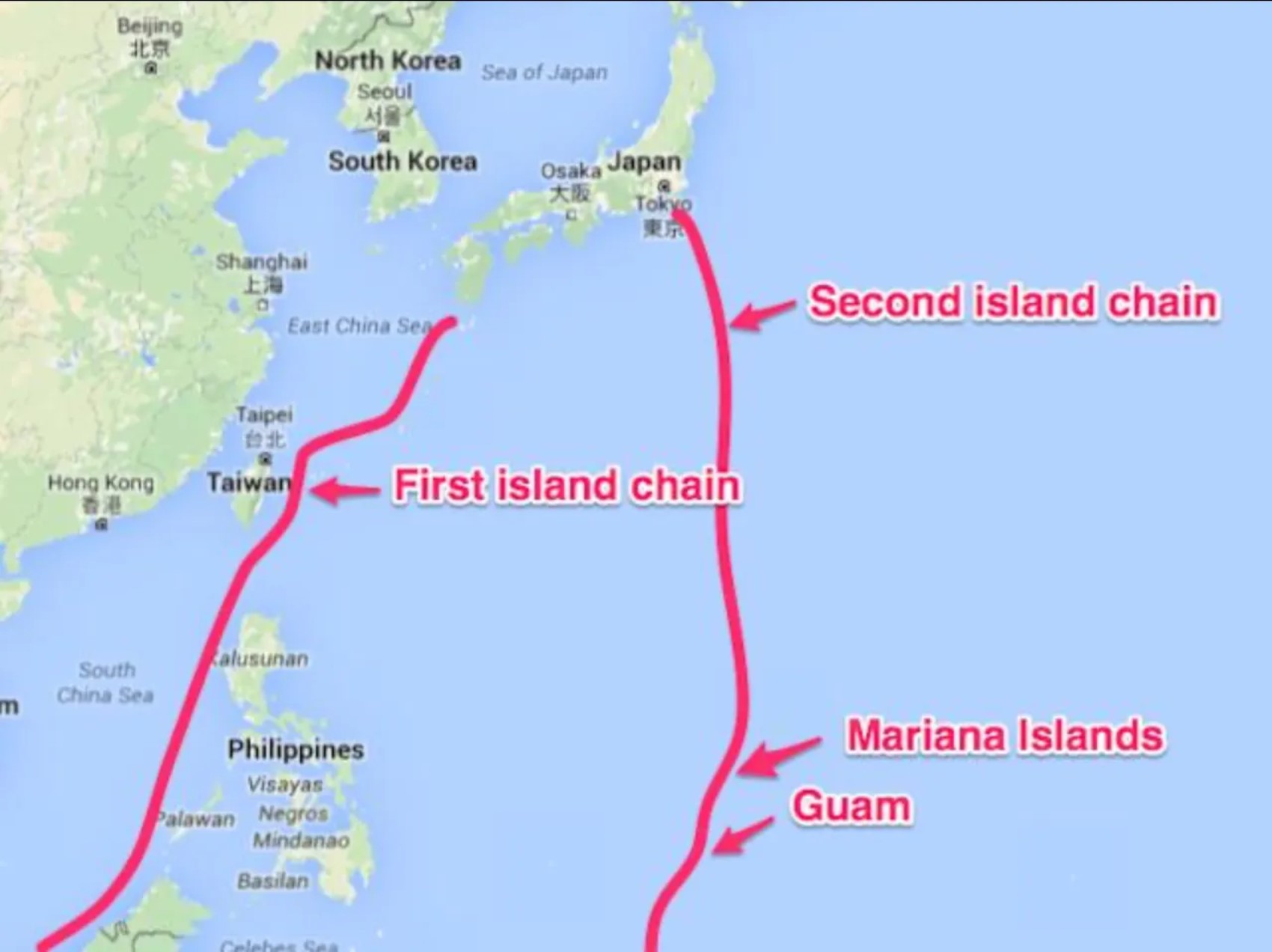
When looking at China’s geography, a major disadvantage is seen at first glance. The Chinese coast is surrounded by the First Island Chain, which stretches along Japan, the Ryukyu Islands, Taiwan, and the Philippines. The Chinese Navy, which wants to exit the Yellow Sea, the East China Sea, and the South China Sea into the Pacific, must overcome this geographical belt. However, the First Island Chain is not an unbroken wall. For a war centered on Taiwan, three regions are particularly important. The Miyako Strait, the Yonaguni-Taiwan passage, and the Luzon/Bashi system allow passage to the ocean. Of course, in the event of war, none of these passages are automatically safe for China. The US, Japan, and the Philippines’ land-based anti-ship missiles, UCAVs, submarines, aircraft, and sensors can threaten these passages. The real strategic difference is what lies beyond the passage. When China succeeds in moving an aircraft carrier strike group outside the First Island Chain, it encounters the Second Island Chain.
This chain is a strategic belt that extends further east of the First Island Chain, along the Western Pacific, and whose center of gravity is formed by the US’s Guam and Northern Mariana Islands. This line generally extends from Japan’s Ogasawara (Bonin) Islands and Iwo Jima in the north, to Saipan and Tinian in the US-affiliated Northern Mariana Islands, then to Guam, and further south to the Federated States of Micronesia and Palau. The military center of gravity of this chain is Andersen Air Force Base and Guam Naval Base. However, both bases are within the range of Chinese firepower.
Geographically, while the First Island Chain creates a relatively narrow and congested maritime area close to the Chinese coast, surrounded by straits and passages, the Second Island Chain spreads over a much wider oceanic geography. For this reason, while the restrictive nature of the First Island Chain stems largely from the geography itself, narrow passages, and dense sensor-weapon networks, the military effectiveness of the Second Island Chain relies not on geographical enclosure but on the US’s forward bases, air and naval power, long-range strike systems, and reconnaissance-surveillance networks, primarily in Guam and the Northern Mariana Islands. In other words, the First Island Chain is a stronger geographical barrier, while the Second Island Chain is a strategic belt that gains meaning largely through the US military base and force network within the vast Pacific area. If an analogy were to be made, the First Island Chain could be likened to the Aegean Sea, and the Second Island Chain to the Mediterranean. However, both have the Pacific Ocean behind them. For China, accessing the vast areas of the Pacific Ocean is much easier than Turkey’s access to the Atlantic and Indian Oceans.
The strategic depth provided by China’s crossing of the first and second island chains is not limited to the opportunity to utilize vast oceanic areas. The Solomon Islands and Kiribati stand out as two critical Pacific island states that could provide forward logistics access for China in the future. While the security agreement China signed with the Solomon Islands in 2022 creates a framework that could provide Beijing with ship visits and logistics support under certain conditions, the location of the Solomons in the South Pacific is important for the Chinese Navy to support its operations thousands of kilometers away from its main bases. Kiribati, on the other hand, has a much wider strategic geography. The fact that the islands it possesses extend to the Central Pacific creates significant potential for China in the long term in terms of ports, airports, and dual-use logistics infrastructure. Although there is no permanent Chinese naval base in these two countries today similar to the one in Djibouti, the political, economic, and security relations Beijing has developed could create significant options for replenishment, port access, and forward logistics support in the future. Therefore, China’s crossing of the island chains means not only the opportunity to move high-value naval assets into the strategic depth of the vast Pacific, but also the potential to create a distributed logistics network in the future via the Solomon Islands-Kiribati axis.
TURKEY’S PROBLEM: THE OCEAN DOES NOT BEGIN WHEN YOU LEAVE THE AEGEAN
Turkey’s geography is almost the opposite. The Aegean Sea is an extremely complex operational area fragmented by hundreds of islands, islets, and rocks. In today’s conditions, where land-based radars, electro-optical systems, UCAVs, electronic intelligence assets, aircraft, anti-ship missiles, and submarines are networked together, the operational width of the Aegean is shrinking even further. Moreover, leaving the Aegean does not bring Turkey to the ocean. Even when the Eastern Mediterranean is reached, the strategic depth problem of a large surface element does not disappear. The Eastern Mediterranean between Crete, Cyprus, the Levant coast, and North Africa is not the Philippine Sea or the Western Pacific. As satellite reconnaissance, synthetic aperture radars, UAVs, maritime patrol aircraft, electronic intelligence, and long-range precision strike systems develop, the potential area where a large platform can be located is gradually narrowing. For this reason, in the 21st century, the physical size of the seas and their military size are no longer the same thing. As sensor and weapon ranges grow, the Aegean and Eastern Mediterranean are shrinking from a military perspective.
The kind of oceanic depth that China can reach by crossing a belt of approximately a few hundred nautical miles does not exist for Turkey. For our 60,000-ton aircraft carrier to reach the Atlantic, it must cross the entire Mediterranean to the Strait of Gibraltar; to reach the Indian Ocean, it must cross the Eastern Mediterranean, Suez, the Red Sea, and the Bab-el-Mandeb line. It is clear that after a high-intensity war begins, these distances and narrow passages cannot be evaluated under peacetime sailing conditions.
THE ESSENTIAL QUESTION OF THE AIRCRAFT CARRIER DEBATE: SURVIVABILITY
Turkey’s aircraft carrier project is an extremely important technological threshold in terms of the shipbuilding, defense industry, and naval aviation capacity the country has reached. Furthermore, such a platform can provide significant power projection capability when Turkey needs to demonstrate military and political presence in the Indian Ocean, Africa, or more distant areas of interest in the future. Therefore, the issue that needs to be discussed is not “Can Turkey build an aircraft carrier?” The real question is, can Turkey ensure the survivability of this platform in a high-intensity regional war? This question should be asked especially regarding the first days of the war.
It cannot be assumed that a high-intensity conflict in which Turkey will be involved in the future will remain on only one front. The war can escalate horizontally in a very short time and spread to the air, sea, space, cyber, and electromagnetic spectrum. In a multi-axis threat environment that Turkey may face in the Eastern Mediterranean, large and high-value surface elements may be exposed to intense Reconnaissance-Surveillance and long-range strike pressure from the beginning of the war.
In particular, it should be taken into account that the sensor, air, submarine, and long-range strike capabilities of Greece, the GCA, Israel, and French and American elements that may be in the region could be present in the same operational environment. This does not mean that these countries will necessarily implement a joint war plan, but Turkish force planning must account for the most negative and highest-intensity scenario. An aircraft carrier does not move alone. It requires air defense ships, anti-submarine warfare elements, submarines, and logistics support ships to protect it against air, surface, and submarine threats, as well as airborne early warning support. Thus, instead of a single ship that needs to be protected, a large and expensive system of systems emerges. More importantly, the loss of such a platform is not just a loss of military capability and national wealth. The loss of a very high-cost national platform and the aircraft accompanying it can create disproportionate results in terms of psychological, political, and prestige aspects, in addition to economic damage. Therefore, the strategic cost of unit loss in large platforms is extremely high.
THE FIRST 72 HOURS OF WAR
For this reason, one of the most important questions that should be asked in future force planning is which forces will be able to survive the first 24, 48, and 72 hours intact when the war begins. A platform’s firepower on paper may be very high. However, if it can be continuously tracked by the enemy’s satellite, radar, electronic intelligence, AI-supported targeting, and long-range missile networks, there is no guarantee that this firepower will not be used in the later stages of the war. Here, survivability is the prerequisite for firepower. A weapon that cannot be hit is often a more powerful weapon. A platform that cannot be found is the hardest platform to hit. For this reason, stealth, mobility, deception, surprise, and the tolerability of loss must become the fundamental design criteria in Turkey’s force structure.
ACCESS DENIAL AND AREA DENIAL ARCHITECTURE FOR TURKEY
Submarines, unmanned surface vehicles, unmanned underwater vehicles, UAVs/UCAVs, shore-based mobile anti-ship missiles, long-range cruise and ballistic missiles, mines, electronic warfare systems, decoys, and widely distributed sensor networks should not be seen as independent systems, but as parts of a single access denial and area denial ecosystem. Instead of concentrating firepower on a few very expensive platforms, spreading it across hundreds of mobile, concealable, and distributable nodes should be preferred for coastal waters with high intensity and traffic volume, such as the Aegean and Eastern Mediterranean.
Mobile missile batteries on land should be kept in underground facilities, mountain shelters, hardened bunkers, and tunnels, as in the approach developed by Iran, and fake positions and constantly relocating mobile systems should be utilized. The goal is not just to protect the weapon. It is to distribute the enemy’s intelligence, reconnaissance, surveillance, and targeting capacity among as many targets as possible, and to make the distinction between a real target and a fake target difficult. Unmanned surface and underwater vehicles can be used for reconnaissance, surveillance, electronic warfare, mining, deception, and, when necessary, missile-carrying missions. One of their significant advantages is that their loss does not create the same strategic and psychological result as the loss of large manned platforms.
THE REAL LESSON TO BE LEARNED FROM CHINA
The Chinese model gains importance again at exactly this point. If we look at what China is doing only through the new aircraft carrier named Fujian, we will draw the wrong conclusion. China is also developing a multi-layered access denial and area denial system that will make it extremely risky for American aircraft carriers to approach its own coasts and critical operational areas. Long-range ballistic and cruise missiles, hypersonic weapons, submarines, bombers, unmanned systems, electronic warfare, and space-based reconnaissance and targeting systems are parts of this. In the approach China envisions against distributed American naval elements, the first target is not directly the aircraft carrier. It is the depletion of the ammunition stocks of the ships that will protect it. First, the defense network is broken, then different attack layers consisting of cheap decoys, low-altitude cruise missiles, and hypersonic weapons are activated. What is important here is not the performance of a single missile, but the war of systems.
SUBMARINE AND LONG-RANGE MISSILE
The submarine is one of the last major platforms that can hide in an increasingly transparent battlefield. The approximate region of a land missile battery can be discovered. A large surface ship can be tracked by space- and air-based reconnaissance. The coordinates of air bases are known. But it may not be known where a silent submarine is.
The combination of the submarine with long-range anti-ship/land-attack missiles therefore creates an extremely powerful strategic effect. China’s work on new-generation hypersonic anti-ship missiles launched from submarines is important in this respect. It is necessary to take it as an example. In this context, the solid fuel, guidance, control, terminal maneuver, and long-range precision strike technologies gained with Roketsan’s Tayfun program can be transferred to the maritime environment. Atmaca/Gezgin-derivative long-range weapons that can be used encapsulated from torpedo tubes for existing submarines could constitute one stage. In the next stage, solutions that can allow for larger missile systems in the MİLDEN design should be considered.
The ability of Turkish submarines to threaten high-value naval and land targets hundreds of kilometers away without revealing their location changes the operational plans of the opposing side from peacetime onwards. The commander of an aircraft carrier or a large surface task group is forced to take into account that they may be within the weapon range of Turkish submarines, even though they do not know where they are located. The real deterrent effect of access denial emerges exactly here.
LOSS-TOLERABLE FORCE
One of the important concepts in the war of the future will be systems whose loss can be tolerated when necessary. This does not mean producing cheap and worthless weapons. On the contrary, it means reducing the strategic vulnerability that would be created by concentrating war power in a few extremely expensive platforms. The loss of an aircraft carrier can turn into a national trauma. The loss of an unmanned maritime vehicle, however, can be part of the mission planning. Hundreds of unmanned vehicles are lost, but the remaining ones can continue their missions. Thus, while the opponent’s hundreds of millions of dollars worth of sensor and missile systems are kept busy with much lower-cost targets, the survival probability of the actual strike elements is increased. For this reason, the ratio between manned and unmanned systems in Turkey’s future force structure should be rethought. Equipping unmanned surface and underwater vehicles with missile, electronic warfare, reconnaissance, surveillance, mining, and deception missions is extremely compatible with Turkey’s geographical conditions in narrow seas.
ABANDONING LARGE PLATFORMS?
The conclusion that “Turkey should not build any large platforms” should not be drawn from this. Turkey is not just an Aegean and Eastern Mediterranean state. It is possible for its economic and strategic interests to grow in the Red Sea, the Horn of Africa, the Indian Ocean, and more distant maritime areas in the future. In this case, aircraft carriers and other large power projection platforms can gain meaning. However, the geography of deployment should be rethought here. Turkey developing long-term naval logistics infrastructure in friendly countries that can provide direct access to the Indian Ocean, such as Somalia, could allow large platforms to be located in regions much closer to the open ocean instead of trying to cross the entire Eastern Mediterranean, Suez, the Red Sea, and Bab-el-Mandeb after a crisis or war begins. The strategic value of this thought is great. Because the survivability problem of a large power projection platform is not solved only by the air defense system it possesses. Geographical deployment is also a defense system. It is important to emphasize that Turkey’s potential naval presence in Libya and its growing military presence in Somalia/Red Sea can create simultaneous power projection in the Mediterranean and the Red Sea in this respect. Thus, Turkey’s naval strategy can be thought of in two separate but complementary layers:
CONCLUSION: GEOGRAPHY MUST DETERMINE FORCE STRUCTURE
This is the most important lesson the comparison between China and Turkey teaches us. China is under serious geographical pressure within the First Island Chain. However, after passing critical gates like Miyako or Luzon/Bashi, it can reach the massive strategic depth of the Philippine Sea and the Western Pacific. Beyond the Second Island Chain, the oceanic depth grows even further. Turkey, on the other hand, cannot obtain the same advantage when it crosses the Aegean.
The Eastern Mediterranean is still a limited operational area under the influence of land-based air power, missiles, submarines, and increasingly developing Intelligence, Reconnaissance, and Surveillance systems. To reach the Atlantic, a long and critical path full of passages must be crossed to Gibraltar, and to reach the Indian Ocean, to Bab-el-Mandeb. For this reason, comparing the aircraft carrier needs of the two countries solely through economic capacity, navy size, or prestige is strategically misleading. There is an ocean behind China’s aircraft carrier. Behind Turkey’s aircraft carrier, however, lie increasingly transparent narrow seas.
The lesson to be learned from China is therefore to develop both the aircraft carrier that will project power to distant seas by taking the Pacific Ocean behind it, and the access denial and area denial architecture that will not allow the opponent’s high-value elements to approach its own coasts, together.
Turkey also needs to shape its force structure according to the conditions of its own geography. Submarines, long-range and future hypersonic anti-ship weapons, unmanned armed surface and underwater vehicles, shore-based mobile missile batteries, mines, electronic warfare, underground-protected missile infrastructure, and distributed sensor networks should form the foundation of this architecture. Because in the high-intensity war of the future, possessing the largest, most expensive, or most flashy platform will not provide superiority on its own. The real superiority will be in the force that can still see, still communicate, still move, and still fire after surviving the first blow. This should also be the fundamental measure of Turkey’s future naval force structure.
Most Read
Passenger ship capsizes off the coast of Kyrenia
First images from the ship that capsized in Kyrenia
As Turkey's future is reshaped, what did your politics think?

Grave allegation from a passenger who survived the ship that sank in Kyrenia!

Rental agreements may become mandatory on e-Government

First image of Cem Yılmaz after being hospitalized

Account manager arrested in beauty center investigation

China’s ocean, Turkey’s narrow seas
Death toll in IETT accident rises to 3

Statement from the Ministry of Interior regarding the ship accident in Kyrenia