




According to the latest assessments made by the General Directorate of Meteorology (MGM), it is estimated that the country will be mostly cloudy, with precipitation expected across the country (excluding the surroundings of Iğdır and Van).
Precipitation, which will generally be in the form of rain and showers, is expected to be sleet and snow in the higher parts of the Inner Aegean and Central Anatolia, the higher parts of the inner sections of the Western and Eastern Black Sea, the north and east of Eastern Anatolia, and the higher parts of Kırklareli, Bursa, and Bilecik. The precipitation is expected to be heavy, and in some places very heavy and severe, in Marmara, the Western and Eastern Black Sea, the west of Central Anatolia, the Eastern Mediterranean, the south and west of Eastern Anatolia, Southeastern Anatolia, and the surroundings of Çorum, Samsun, Giresun, Gümüşhane, and Bayburt.
Air temperatures are expected to drop significantly (2°-10°C) in the northern, inner, and western regions due to the rainy weather, falling below seasonal norms, while no significant change is expected elsewhere. The wind is expected to blow from the south and west, shifting to the north and northwest in Marmara, the Coastal Aegean, and the Mediterranean, with moderate to occasionally strong intensity. It is expected to blow as a strong and short-term storm (50-80 km/h) from northerly directions in Marmara, the Aegean, and the Western Mediterranean, and from southerly directions in the Black Sea, Central Anatolia, the Eastern Mediterranean, and Eastern and Southeastern Anatolia, and as a very strong and full storm (80-110 km/h) in the north of Marmara and the coasts of the Western Black Sea.
HEAVY PRECIPITATION AND WIND WARNING
In its heavy precipitation warning, the MGM stated, "Since the precipitation is expected to be heavy, and in some places very heavy and severe, in Marmara, the Western and Eastern Black Sea, the west of Central Anatolia, the Eastern Mediterranean, the south and west of Eastern Anatolia, Southeastern Anatolia, and the surroundings of Çorum, Samsun, Giresun, Trabzon, Gümüşhane, and Bayburt, it is necessary to be careful and cautious against negative consequences such as flash floods, local flooding, and overflows." In its strong wind warning, it stated, "Since the wind is expected to blow as a strong and short-term storm (50-80 km/h) from northerly directions in Marmara, the Aegean, and the Western Mediterranean, and from southerly directions in the Black Sea, Central Anatolia, the Eastern Mediterranean, and Eastern and Southeastern Anatolia, and as a very strong and full storm (80-110 km/h) in the north of Marmara and the coasts of the Western Black Sea, it is necessary to be careful and cautious against negative consequences such as roof dislodgement, tree falls, disruptions in transportation, and stove and flue gas poisoning."
ISTANBUL GOVERNOR GÜL ALSO ISSUED A WARNING
Istanbul Governor Davut Gül said in a post on his social media X account, "The ongoing precipitation in Istanbul is expected to remain effective tomorrow. The wind is expected to increase in intensity and blow from the north and northwest, occasionally as a full storm (90-110 km/h). Please be careful and cautious against any negative consequences that may occur."
AFAD ISSUES PROVINCE-BY-PROVINCE WARNING
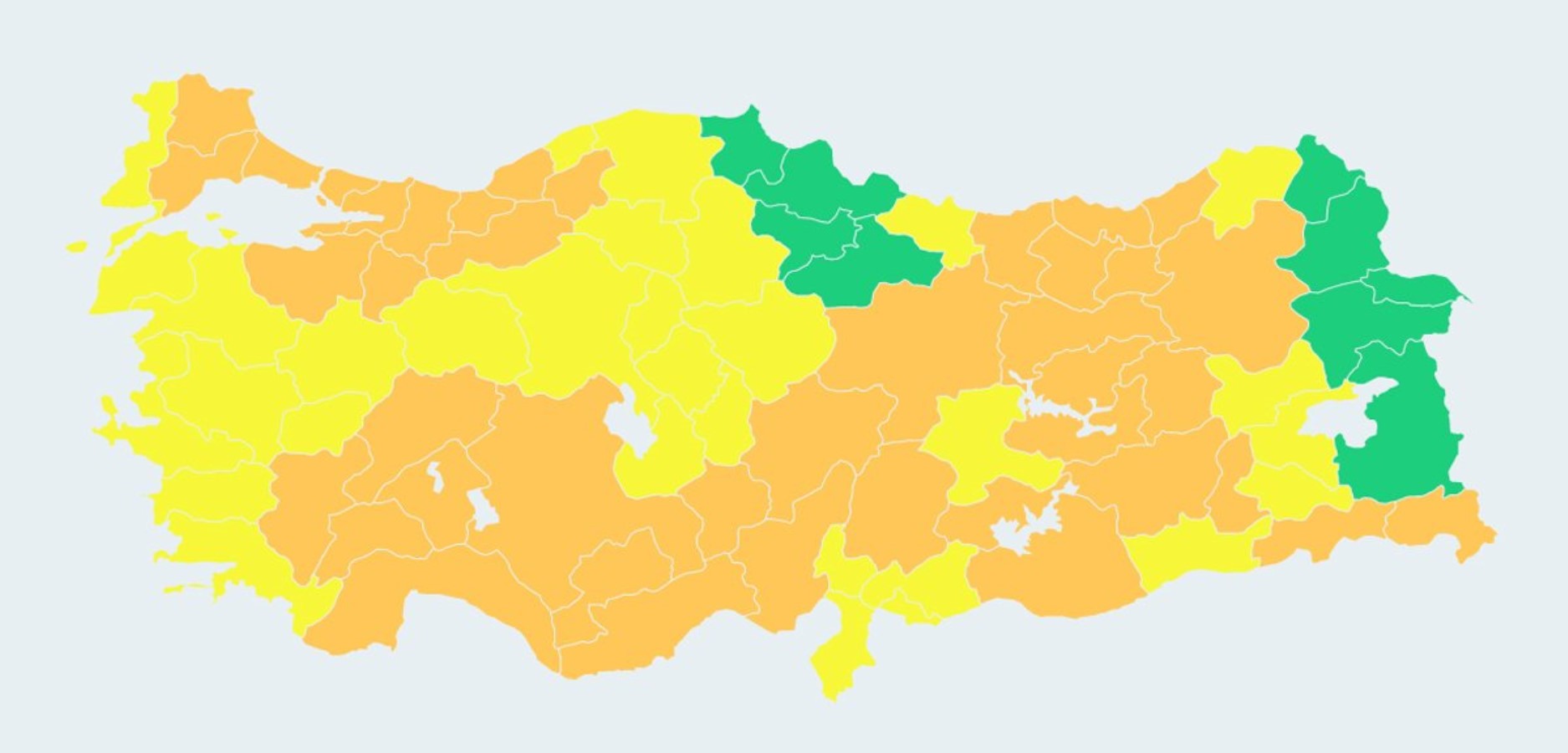
AFAD announced that meteorological warnings have been issued for a total of 72 provinces, with orange alerts for 41 provinces and yellow alerts for 31 provinces regarding today. The statement from AFAD read as follows:
“Orange alert: Adana, Adıyaman, Afyonkarahisar, Antalya, Batman, Bayburt, Bilecik, Bingöl, Bolu, Burdur, Bursa, Denizli, Diyarbakır, Düzce, Elazığ, Erzincan, Erzurum, Giresun, Gümüşhane, Hakkari, Isparta, Istanbul, Mersin, Kahramanmaraş, Karabük, Karaman, Kayseri, Kırklareli, Kocaeli, Konya, Niğde, Rize, Sakarya, Sivas, Tekirdağ, Trabzon, Tunceli, Şanlıurfa, Şırnak, Yalova, and Zonguldak.
Yellow alert: Aksaray, Ankara, Artvin, Aydın, Balıkesir, Bartın, Bitlis, Çanakkale, Çankırı, Çorum, Edirne, Eskişehir, Gaziantep, Hatay, Izmir, Kastamonu, Kırıkkale, Kırşehir, Kilis, Kütahya, Malatya, Manisa, Mardin, Muğla, Muş, Nevşehir, Ordu, Osmaniye, Siirt, Uşak, and Yozgat.
Governorships, district governorships, and provincial AFAD directorates in the provinces under warning have been notified. Our teams are on alert in provinces where yellow and orange meteorological warnings have been issued, and they are responding rapidly to incoming reports. We strongly remind our citizens to be cautious against negative conditions such as floods, flash floods, lightning, landslides, local hail, roof detachment, tree/pole toppling, stove/chimney poisoning, icing, and frost, as well as disruptions in transportation.”
NOVEMBER 19 WEATHER FORECAST
MARMARA
It is estimated that the region will be mostly cloudy with rain and showers throughout, while higher elevations in the Kırklareli, Bursa, and Bilecik areas are expected to see sleet and snow. Precipitation is expected to be heavy across the region, and very heavy to locally severe in the Kocaeli, Yalova, Bursa, Bilecik, and Sakarya areas. The wind is expected to blow from the north and northwest as strong and short-term storms (50-70 km/h), and as very strong and full storms (80-110 km/h) along the coasts.
EDIRNE 6°C, 11°C
It is expected to be very cloudy with intermittent rain and showers. The precipitation is expected to be heavy tonight.
ISTANBUL 5°C, 9°C
It is expected to be very cloudy with intermittent rain and showers. The precipitation is expected to be heavy on Sunday morning.
KIRKLARELI 3°C, 7°C
It is expected to be very cloudy with intermittent rain and showers, with sleet and snow in higher elevations during the night. The precipitation is expected to be heavy tonight.
KOCAELI 5°C, 9°C
It is expected to be very cloudy with intermittent rain and showers. The precipitation is expected to be very heavy and locally severe starting from Sunday morning.
AEGEAN
It is expected to be partly to mostly cloudy, with rain and showers across the region, and sleet and snow in the higher elevations of Uşak, Afyonkarahisar, and Kütahya. The wind is expected to blow strongly from the north and northwest in the coastal and inner Aegean, occasionally reaching storm force (50-80 km/h).
AFYONKARAHİSAR 2°C, 5°C
Partly to mostly cloudy, with intermittent rain and showers, and sleet and snow in higher elevations.
DENİZLİ 4°C, 10°C
Partly to mostly cloudy, with rain and showers on Sunday morning.
İZMİR 9°C, 13°C
Partly to mostly cloudy, with showers this evening.
MUĞLA 1°C, 10°C
Partly to mostly cloudy, with showers expected this evening
MEDITERRANEAN
It is expected to be partly to mostly cloudy, with intermittent showers and occasional thunderstorms across the region. Precipitation is expected to be heavy in the vicinity of Mersin and Adana and the eastern districts of Antalya, and very heavy to severe in the Eastern Mediterranean. Winds are expected to blow from the north in the Western Mediterranean and from the south in the Eastern Mediterranean, reaching strong levels and occasionally turning into storms (50-80 km/h).
ADANA 15°C, 21°C
Mostly cloudy, with intermittent showers and thunderstorms, which are expected to be heavy
ANTALYA 13°C, 16°C
Mostly cloudy, with showers expected this evening
HATAY 13°C, 20°C
It is expected to be very cloudy with intermittent showers and thunderstorms. The precipitation is expected to be very heavy and intense.
MERSİN 16°C, 20°C
Very cloudy, with intermittent showers and thunderstorms, expected to be heavy this evening.
CENTRAL ANATOLIA
Partly to very cloudy, with rain and showers expected across the region. Higher elevations of Eskişehir, Ankara, Karaman, Niğde, Kayseri, Yozgat, and Sivas are expected to see sleet and snow. Precipitation is expected to be heavy in the south and west. The wind is expected to blow strongly from the south and southwest in the northwest of the region, occasionally reaching storm force (50-80 km/h).
ANKARA 2°C, 6°C
Very cloudy, with intermittent showers and occasional thunderstorms; higher elevations are expected to see sleet and snow after Sunday afternoon. Precipitation is expected to be heavy this evening.
ESKİŞEHİR 1°C, 2°C
It is expected to be mostly cloudy with intermittent sleet and snowfall. The precipitation is expected to be heavy by Sunday afternoon.
KONYA 2°C, 8°C
It is expected to be mostly cloudy with rain and showers by Sunday afternoon. The precipitation is expected to be heavy in the evening hours.
YOZGAT -1°C, 5°C
Mostly cloudy, with rain and sleet expected this evening and overnight.
WESTERN BLACK SEA
It is expected to be mostly cloudy with precipitation across the region. The precipitation, which is expected to fall generally as rain and showers, and as sleet and snow in the interior and higher elevations, is expected to be very heavy and intense.
BOLU 2°C, 3°C
It is expected to be very cloudy with intermittent rain and sleet, turning into snow over time. Precipitation is expected to be very strong and severe, with heavy snowfall in higher elevations.
DÜZCE 6°C, 9°C
Very cloudy, with intermittent rain and showers, which may be very strong and severe in some areas.
KASTAMONU 2°C, 7°C
It is expected to be very cloudy with intermittent rain and showers, with sleet and snow in higher elevations. Precipitation is expected to be strong this evening.
ZONGULDAK 7°C, 12°C
It is expected to be very cloudy with intermittent rain and showers. Precipitation is expected to be strong.
CENTRAL AND EASTERN BLACK SEA
It is expected to be very cloudy with precipitation across the region. The precipitation, which is expected to occur generally as rain and showers, and as sleet and snow in the inland and high-altitude areas, is expected to be heavy in the vicinity of Çorum, Samsun, Giresun, Gümüşhane, and Bayburt. The wind is expected to blow from the south and southwest in the inland parts of the Eastern Black Sea as strong and short-term storms (50-80 km/h).
AMASYA 8°C, 11°C
Very cloudy, with intermittent rain and showers
SAMSUN 13°C, 18°C
It is expected to be very cloudy with intermittent rain and showers. The precipitation is expected to be heavy this evening.
TOKAT 6°C, 10°C
Very cloudy, with intermittent rain and showers
TRABZON 15°C, 17°C
Very cloudy, intermittent rain and showers
EASTERN ANATOLIA
Partly to very cloudy, with precipitation expected across the region (except for Iğdır and Van). The precipitation, which is expected to be generally in the form of rain and showers, and sleet and snow in the higher parts of the north and around Hakkâri, is expected to be heavy in the vicinity of Bingöl, Muş, and Bitlis, and very heavy and intense in the vicinity of Malatya, Elazığ, Tunceli, and Erzincan. The wind is expected to blow from the south and southwest as strong and short-term storms (50-80 km/h).
ERZURUM 3°C, 8°C
Very cloudy and intermittently rainy, with sleet and snow expected after Sunday noon
KARS 2°C, 11°C
Very cloudy and intermittently rainy
MALATYA 7°C, 14°C
It is expected to be very cloudy with intermittent showers and thunderstorms. The precipitation is expected to be very strong and severe.
VAN 3°C, 14°C
Very cloudy
SOUTHEASTERN ANATOLIA
It is expected to be very cloudy with showers and thunderstorms across the region. Precipitation is expected to be strong in the vicinity of Mardin, Siirt, Batman, and Diyarbakır, and very strong and severe in the vicinity of Gaziantep, Kilis, Adıyaman, and Şanlıurfa.
DİYARBAKIR 9°C, 13°C
It is expected to be very cloudy with intermittent showers. The precipitation is expected to be strong.
GAZIANTEP 9°C, 14°C
It is expected to be very cloudy with intermittent showers and thunderstorms. The precipitation is expected to be very heavy and intense.
MARDIN 9°C, 10°C
It is expected to be very cloudy with intermittent showers. The precipitation is expected to be heavy.
SIIRT 11°C, 15°C
It is expected to be very cloudy with intermittent showers. The precipitation is expected to be heavy.
News Source: 12punto